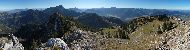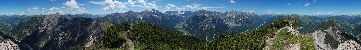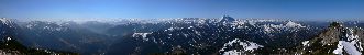
RUCHENKOEPFE (1805m) dist: 8.58km
WILDALPJOCH (1725m) dist: 17.43km
TAGWEIDKOPF (1724m) dist: 16.56km
ROTWAND (1884m) dist: 7.99km
HOCHMIESING (1883m) dist: 8.92km
LAMPERSBERG (1817m) dist: 7.65km
FARRENPOINT (1272m) dist: 20.71km
TAUBENSTEIN (1692m) dist: 7.97km
RAUHKOPF (1689m) dist: 8.39km
AIPLSPITZ (1759m) dist: 9.40km
HEISSENPLATTE (1593m) dist: 10.64km
SCHWARZENKOPF (1464m) dist: 6.99km
BENZINGSPITZ (1735m) dist: 8.95km
WILDE FRAEULEIN (1615m) dist: 8.14km
JAEGERKAMP (1746m) dist: 8.79km
NAGELSPITZ (1554m) dist: 10.00km
STOLZENBERG (1609m) dist: 4.64km
|